Starting a sustainable community walking club requires a measured step-free loop with rest seating every 300 to 500 meters, published pace tiers in kilometers per hour, and a two-volunteer minimum consisting of a Front Walk Leader and a Back-Marker. Launching a group with a vague meeting pin and an unpaced pack fails newcomers and mobility-aid users on the first outing when faster walkers pull ahead and leave slower participants isolated behind blind corners.
Organisers searching for how to start a walking club often focus on social promotion before auditing the physical corridor. When a resident searches for a walking club near me, they need concrete operational facts before leaving home: exact tread width, maximum slope, toilet availability at the meeting hub, conversational pace expectations, and whether they can turn back after 15 minutes without holding up the group. This guide builds on the foundational measurements in how to organise an inclusive walk and translates public pedestrian standards into a repeatable group operating model for Walking and Conversation organisers.
| Pace Tier Cohort | Target Speed Range | Pace per km (and Mile) | Energy Cost (2024 Compendium METs) | 35–45 Min Loop Distance | Rest Stop Cadence and CDC Talk Test Standard |
|---|---|---|---|---|---|
| Tier A: Gentle and Social Stroll (Rollator and Wheelchair Friendly) | 3.0–3.8 km/h (1.8–2.4 mph) |
16–20 min/km (25–33 min/mi) |
2.5–2.8 METs (Codes 17152 / 17170) |
1.5–2.5 km (0.9–1.5 mi) |
3-minute pause at an accessible bench every 300–400 m; unhurried full sentences with zero breathlessness |
| Tier B: Conversational Community Walk (Neighbourhood Anchor) | 4.0–4.8 km/h (2.5–3.0 mph) |
12.5–15 min/km (20–24 min/mi) |
3.0–3.5 METs (Codes 17170 / 17190) |
2.8–3.6 km (1.7–2.2 mi) |
2 scheduled bench/water pauses per loop; complete sentences spoken comfortably without gasping |
| Tier C: Brisk Purposeful Walk (Continuous Exercise Loop) | 5.0–5.8 km/h (3.1–3.6 mph) |
10.3–12 min/km (16.5–19 min/mi) |
4.3 METs (Code 17200) |
3.8–4.8 km (2.4–3.0 mi) |
1 mid-route water and turnaround pause; shorter phrases with noticeable breathing elevation |
Step 1: Audit a Step-Free Loop and Start Hub Using PROWAG R302 Standards
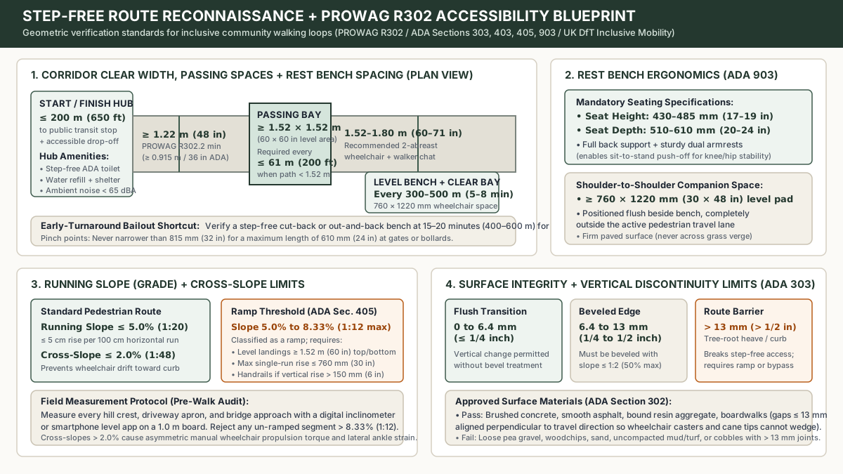
A community walking club succeeds or fails at its start hub and narrowest pinch point. Before announcing a launch date, walk the candidate loop with a measuring wheel, a 1.0-meter straightedge, a digital inclinometer (or calibrated smartphone clinometer), and a tape measure. Under U.S. Access Board Public Right-of-Way Accessibility Guidelines (PROWAG Section R302) and the 2010 ADA Standards for Accessible Design (Sections 302, 303, 403, 405, and 903), an inclusive pedestrian access route must satisfy strict geometric thresholds so wheelchair users, rollator users, and walking companions travel on the exact same path.
Start and Finish Hub Selection Criteria
Select a permanent, recognizable start and finish hub that eliminates arrival friction:
- Transit and step-free drop-off proximity: Position the meeting point within
<= 150–200 m(500–650 ft) of a public bus or rail stop and an accessible passenger drop-off bay with flush curb ramps. - Unlocked accessible restroom and water access: Confirm an operational, step-free public toilet (with a
>= 1.52 m/60 ininternal turning circle and grab bars) and a drinking water refill station at the hub. Never rely on a commercial cafe toilet that requires a purchase or unlocks after your morning start time. - Acoustic and weather staging: Choose a sheltered pavilion, library portico, or tree-canopied plaza where ambient background traffic noise remains below
65 dBAso the 3-minute pre-walk briefing is audible without shouting. - 15-minute bailout shortcut: Map an out-and-back spur or cross-path shortcut that allows any participant to return to the start hub at the
15–20 minutemark (400–600 mout) without navigating complex street crossings alone.
Corridor Width, Slope, Surface, and Bench Verification
Apply this physical community walking group checklist across every meter of the loop before publishing the route sheet:
| Route Engineering Parameter | ADA / PROWAG / Inclusive Mobility Standard | Field Measurement Method and Operational Failure Mode |
|---|---|---|
| Continuous Clear Width | >= 1.22 m (48 in) under PROWAG R302.2; >= 915 mm (36 in) ADA temporary event minimum; 1.52–1.80 m (60–71 in) for side-by-side conversation |
Measure between fixed obstacles (bollards, lamp posts, overgrown hedges). Paths narrower than 1.52 m force single-file walking and block conversation between a wheelchair user and a companion. |
| Passing Space Interval | >= 1.52 m × 1.52 m (60 in × 60 in) level bay at intervals <= 61 m (200 ft) when path width is < 1.52 m (PROWAG R302.3 / ADA 403.5.3) |
Confirm paved widenings or intersecting flat paths every 61 m so two wheelchairs or rollators can pass without dropping a wheel onto soft mud or grass. |
| Running Slope (Longitudinal Grade) | <= 5.0% (1:20, or <= 5 cm rise per 100 cm run); segments 5.0%–8.33% (1:12 max) are ramps (ADA Sec. 405) |
Check bridge approaches and park hills. Any ramp segment > 5.0% requires 1.52 m (60 in) level landings at top and bottom, max rise <= 760 mm (30 in), and handrails if rise exceeds 150 mm (6 in). Reject any un-ramped slope > 8.33%. |
| Cross-Slope (Lateral Tilt) | <= 2.0% (1:48 under ADA 403.3; <= 2.1% under PROWAG R302.5) |
Measure perpendicular to travel across driveway aprons and cambered paths. Cross-slopes above 2.0% force manual wheelchair users to apply continuous one-armed corrective torque and strain walkers’ ankles. |
| Surface and Vertical Discontinuities | Firm, stable, slip-resistant; vertical lips <= 6.4 mm (1/4 in) flush; 6.4–13 mm (1/4–1/2 in) beveled at <= 1:2 (50%); > 13 mm (1/2 in) prohibited without ramp (ADA Sec. 303) |
Inspect tree-root heaves, expansion joints, and drainage grates (openings must be <= 13 mm / 1/2 in perpendicular to travel). A single un-ramped 20 mm lip stops a front wheelchair caster dead. |
| Rest Bench Spacing and Ergonomics | Bench every 300–500 m (985–1,640 ft); seat height 430–485 mm (17–19 in), depth 510–610 mm (20–24 in), backrest, armrests, plus 760 × 1,220 mm (30 × 48 in) adjacent level bay (ADA Sec. 903 / UK DfT Inclusive Mobility) |
UK Inclusive Mobility specifies 50–150 m seating intervals in core pedestrian zones; for park loops, never exceed 300–500 m between benches with sturdy armrests (essential for sit-to-stand push-off) and a paved companion bay beside the bench. |
When your walking club pairs an outdoor loop with an indoor gathering room or community hall check-in, run the room and entrance audit in our accessibility checklist for a community event. For instrument-by-instrument outdoor field measurements covering ASTM F1951 caster sinkage, PROWAG R304 curb ramps, and PAS 6463 quiet recovery tents, use our accessibility audit checklist for outdoor events and routes.
Takeaway: Never label a route “accessible” or “easy” from a desktop map; walk the loop with a tape and clinometer to confirm <= 5.0% running slope, <= 2.0% cross-slope, zero vertical lips over 13 mm, and armrest benches every 300–500 m.
Step 2: Calibrate Pace Tiers and Calculate Route Timing
The most common reason a neighborhood walking club splinters within its first month is mixed-pace friction. When a single group advertises an “all-abilities 45-minute walk” without explicit speed bounds, walkers comfortable at 5.2 km/h (3.2 mph) naturally surge to the front while participants strolling at 3.2 km/h (2.0 mph) experience silent pressure to overexert or drop out.
Prevent pack stretching by defining three transparent tiers grounded in the 2024 Adult Compendium of Physical Activities (Herrmann et al., 2024) and the CDC / ACSM Talk Test:
- Tier A (Gentle and Social Stroll,
3.0–3.8 km/h/1.8–2.4 mph,2.5–2.8 METs): Grounded in Compendium Code17152(walking< 2.0 mph, level, strolling, very slow =2.3 METs) and Code17170(2.5 mph, firm surface =3.0 METs). Designed for unhurried conversation, people using rollators, canes, or wheelchairs, and neighbours returning to outdoor routines. Includes scheduled 3-minute pauses every300–400 m. - Tier B (Conversational Community Walk,
4.0–4.8 km/h/2.5–3.0 mph,3.0–3.5 METs): Grounded in Compendium Code17170(3.0 METs) and Code17190(2.8–3.2 mph, level, moderate pace =3.5 METs). Participants speak in complete sentences without gasping (passing the CDC Talk Test for moderate-intensity activity). This serves as the default anchor tier for most neighbourhood and workplace clubs. - Tier C (Brisk Purposeful Walk,
5.0–5.8 km/h/3.1–3.6 mph,4.3 METs): Grounded in Compendium Code17200(3.5 mph, level, brisk, walking for exercise =4.3 METs). Suited for walkers seeking continuous aerobic movement with a single mid-route water check.
Modified Naismith Route Duration Formula and Worked Examples
To guarantee that every tier returns to the start hub inside a published 60-minute community window (leaving 5 minutes for the pre-walk briefing and 5–10 minutes for post-walk social wrap-up), calculate total loop time using the Modified Naismith + Rest-Stop Route Duration Formula:
T_total_min = (D_km / V_kmh) × 60 + (Ascent_m / 10) + (N_stops × t_stop_min)
Where:
D_km= Horizontal route loop distance in kilometers.V_kmh= Slowest advertised speed of the target pace tier in km/h (always calculate using the bottom of the tier bracket so slower walkers are never rushed).Ascent_m= Cumulative vertical climb in meters along the loop (Naismith’s rule adds1 minuteper10 metersof ascent, equivalent to10 minutesper100 meters).N_stops= Number of planned bench regrouping and pedestrian crossing pauses.t_stop_min= Average duration per pause in minutes (typically2–4 minutes).
Worked Example 1 (Tier A Gentle Loop):
Suppose you map a 2.4 km (1.5 mile) step-free park loop for Tier A (3.0–3.8 km/h), using a conservative base speed of V_kmh = 3.2 km/h, with 15 m of cumulative gentle grade and 3 scheduled bench pauses of 3 minutes each:
- Base walking time:
(2.4 / 3.2) × 60 = 45.0 minutes - Grade allowance:
15 / 10 = 1.5 minutes - Regrouping bench pauses:
3 × 3 = 9.0 minutes - Total duration:
T_total_min = 45.0 + 1.5 + 9.0 = 55.5 minutes(fits cleanly inside a 60-minute schedule).
Worked Example 2 (Tier B Conversational Loop):
For a 3.2 km (2.0 mile) Tier B loop calculated at the tier floor V_kmh = 4.0 km/h, with 20 m cumulative rise and 2 bench/water stops of 3 minutes each:
- Base walking time:
(3.2 / 4.0) × 60 = 48.0 minutes - Grade allowance:
20 / 10 = 2.0 minutes - Regrouping pauses:
2 × 3 = 6.0 minutes - Total duration:
T_total_min = 48.0 + 2.0 + 6.0 = 56.0 minutes.
Takeaway: Always size your loop distance using the slowest advertised speed of the tier plus 1 minute per 10 m climb and 3 minutes per bench stop so the cohort finishes on time without rushing the rear walkers.
Step 3: Structure Volunteer Roles and Pack-Spread Ratios
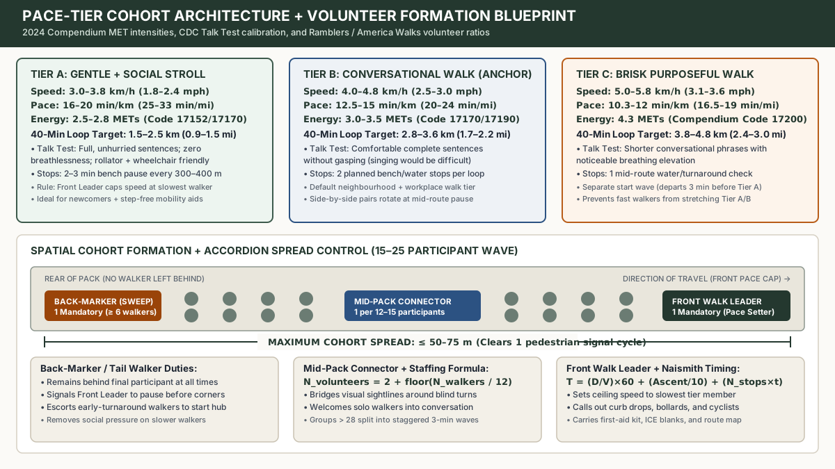
A safe, welcoming walking club never relies on a single organiser walking at the front. Drawing on operational benchmarks from Ramblers UK Wellbeing Walks, the Walk with a Doc Chapter Operations Guide, and America Walks community toolkits, every walk requires a defined spatial formation that keeps the cohort connected and guarantees no participant ever walks alone at the back.
Three Core Volunteer Roles
- Front Walk Leader (Route Navigator and Pace Cap: 1 per cohort):
- Arrives
20 minutesbefore start time to inspect the hub, confirm unlocked restrooms, check local weather/AQI, and greet early arrivals. - Leads the 3-minute pre-walk briefing and walks at the head of the group.
- Caps forward speed at the pace of the slowest participant in that tier, calls out surface hazards (curb drops, wet leaves, bollards, approaching cyclists), and carries the compact first-aid kit, spare blank Pocket ICE cards, and printed route map.
- Arrives
- Back-Marker / Tail Walker (“Sweep”: 1 mandatory per cohort of
>= 6walkers):- Walks immediately behind the final participant at all times so nobody trails behind the group or feels watched for walking slowly.
- Maintains visual line-of-sight (or mobile message/radio contact) with the Front Walk Leader and signals the front to pause before blind turns or road crossings until the tail closes the gap.
- Escorts any participant who chooses to take the
15–20 minuteearly-turnaround shortcut back to the start hub.
- Mid-Pack Connector / Crossing Marshal (“Floater”: 1 per
12–15walkers):- Positioned in the middle third of the cohort to prevent accordion stretching and relay stop signals around corners.
- Rotates gently during the walk to welcome solo newcomers into conversation so nobody walks in unintended isolation.
Volunteer Staffing Formula and Pack Elongation Math
Calculate minimum volunteer headcount for any single walking wave using the Volunteer Staffing Formula:
N_volunteers = 2 + floor(N_participants / 12)
For example, a Saturday morning wave of N_participants = 18 walkers requires N_volunteers = 2 + floor(18 / 12) = 2 + 1 = 3 volunteers (1 Front Walk Leader, 1 Mid-Pack Connector, and 1 Back-Marker). Why is active pack-spread control necessary? Consider the Pack Elongation Equation:
L_spread_m = (V_front_kmh - V_rear_kmh) × (t_interval_min / 60) × 1000
If front walkers drift up to V_front_kmh = 4.6 km/h while rear walkers move at V_rear_kmh = 3.8 km/h, over a t_interval_min = 10 minute uninterrupted stretch the cohort stretches to L_spread_m = (4.6 - 3.8) × (10 / 60) × 1000 = 133.3 meters. A 133-meter spread splits the group across multiple urban traffic signal cycles, breaks visual sightlines, and isolates slower walkers. By capping the front leader’s speed and pausing for 2–3 minutes every 300–500 meters (5–8 minutes), total pack spread remains within <= 50–75 meters.
| Total Participant Turnout | Required Volunteer Formation | Maximum Cohort Spread | Operational Wave Strategy |
|---|---|---|---|
| 1–5 walkers | 1 Front Walk Leader + 1 designated attendee buddy at rear |
<= 25 m |
Single cohesive conversational group |
| 6–14 walkers | 2 volunteers (1 Front Walk Leader + 1 dedicated Back-Marker) |
<= 50 m |
Single cohort; Back-Marker holds line-of-sight with Front Leader |
| 15–28 walkers | 3–4 volunteers (1 Front Leader + 1–2 Mid-Pack Connectors + 1 Back-Marker) |
<= 75 m |
Single wave on wide park paths (>= 1.8 m), or split into two 12–14 person waves staggered 3 minutes apart |
| 29+ walkers | Split into separate Tier A and Tier B cohorts (>= 2 volunteers per tier) |
<= 50 m per sub-group |
Tier B departs 3 minutes before Tier A so faster walkers never crowd or stretch the gentle stroll cohort |
Takeaway: Staff every walk of 6 or more people with a dedicated Back-Marker and add 1 Mid-Pack Connector per 12 to 15 walkers to hold total pack spread under 75 meters.
Step 4: Set Up Pocket ICE Cards, Weather Cutoffs, and the 60-Minute Run-of-Show
Community walk organisers need clear emergency readiness without turning a friendly neighbourhood stroll into a bureaucracy or collecting sensitive health records. Storing participant medical histories on a volunteer’s phone or spreadsheet creates data-privacy risks (including UK GDPR and local privacy rules) and discourages attendance.
Participant-Carried Pocket ICE Card Protocol
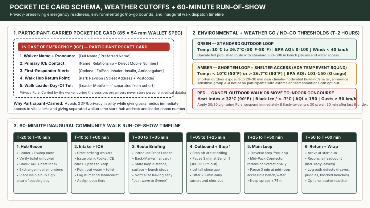
Instead of collecting medical forms, hand every walker a blank, wallet-sized (85 mm × 54 mm) Pocket In Case of Emergency (ICE) Card at their first session. Each participant fills out the card and keeps it in their own jacket pocket, lanyard pouch, or Mobility bag during the walk:
- Participant Full Name and Pronouns: How the person wishes to be addressed by volunteers or responders.
- Primary Emergency Contact (ICE): Name, relationship, and direct telephone number of a family member or friend.
- Optional First-Responder Notes: Self-disclosed critical alerts strictly for paramedics in an emergency (for example: EpiPen location, asthma inhaler, insulin-dependent diabetes, or anticoagulant medication).
- Walk Club Start Hub Address: Printed name and street/postcode of the meeting hub so a walker who steps away can show a passerby or taxi driver exactly where the group started.
- Front Walk Leader Day-Of Mobile Number: Allows a participant who pauses at a restroom or takes an early shortcut to text or call the leader directly.
Pair the Pocket ICE Card with a plain-English welcome notice on your sign-in clipboard and event page. State clearly that participants choose their own pace and distance, can sit on any bench, and can leave early at any point simply by waving to the Back-Marker so the headcount stays accurate. For guidance on writing welcoming, non-clinical invitations that respect personal privacy, see respectful language for mental health conversations. If you are adapting this format for an office, remote, or shift-based team, review the boundaries in limits of walking conversations at work and the structural controls in low-barrier workplace wellness ideas.
Weather, Temperature, and Air Quality Cutoffs (T-2 Hour Check)
Check local meteorological forecasts and US EPA AirNow (or UK Daily Air Quality Index) exactly 2 hours before departure and apply consistent environmental thresholds:
- Temperature and Heat Index bounds: Following ADA Temporary Events guidance (detailed in how to organise an inclusive walk), whenever ambient air temperature rises above
26.7°C(80°F) or drops below10°C(50°F), shorten the outdoor loop to20–30 minutesand ensure immediate access to a temperature-moderated building or shelter. Cancel the outdoor walk or shift to an indoor shopping concourse or community recreation track if the Heat Index reaches>= 32°C(90°F) or if freezing rain, black ice, or windchill below-7°C(20°F) compromises pavement traction. - Air Quality Index (AQI) cutoffs: At AQI
0–100(Green/Yellow), run the normal route. At AQI101–150(Orange: Unhealthy for Sensitive Groups), switch to the shortened Tier A gentle stroll and announce the AQI reading at the briefing so people with asthma, COPD, or cardiovascular conditions can opt out comfortably. At AQI> 150(Red: Unhealthy), cancel outdoor walking. - High winds and lightning: Cancel wooded park or tree-lined routes when sustained winds or gusts reach
>= 50–60 km/h(31–38 mph, Beaufort Force 7) due to falling limb hazards. Enforce the 30/30 Lightning Rule: suspend outdoor walking immediately if thunder follows a lightning flash within30 seconds, and remain inside a substantial building for30 minutesafter the last sound of thunder.
The 60-Minute Inaugural Walk Run-of-Show
Execute your launch walk and every recurring session on a predictable 60-minute clock:
| Clock Window | Operational Phase | Volunteer Actions and Participant Checkpoints |
|---|---|---|
T-20 to T-10 min |
Hub Reconnaissance and Setup | Front Walk Leader and Back-Marker meet at the start hub, confirm the public toilet is unlocked, check temperature and AQI, test mobile phone contact, and place a small clipboard sign beside the meeting bench (leaving the 1.52 m passing space completely clear). |
T-10 to T+00 min |
Welcome, ICE Card Issue, and Headcount | Greet arriving participants, hand out blank Pocket ICE cards and pens for personal keeping, point out water and restrooms, record a numerical headcount, and group walkers into Tier A or Tier B if running two waves. |
T+00 to T+05 min |
3-Minute Plain-Language Briefing | Introduce the Front Leader and Back-Marker (wearing high-visibility lanyards or armbands), state the exact loop distance (km and miles), surface type, bench locations, and the 15–20 minute early-turnaround option. Remind everyone that leaving early requires no explanation, only a quick wave to the Back-Marker. |
T+05 to T+25 min |
Outbound Segment and Bench Stop 1 | Step off at the advertised tier ceiling speed. Pause for 3 minutes at the first accessible bench (300–500 m out) so the tail closes the gap, check group comfort, and allow anyone wanting a 20-minute micro-walk to turn back with a volunteer or buddy. |
T+25 to T+50 min |
Main Loop and Mid-Route Pause | Complete the step-free loop with a second 3-minute water and bench pause at the midpoint. The Mid-Pack Connector rotates conversationally so solo walkers have company if desired, keeping total cohort spread <= 50–75 m. |
T+50 to T+60 min |
Hub Return, Final Headcount, and Defect Log | Return to the starting hub, confirm that the final headcount plus logged early departures matches the starting count, announce next week’s walk time, and record any route maintenance defects (new tree-root heaves, blocked benches, standing water) on the route sheet. |
When your walking club publishes a list of local park hubs, municipal transit links, or neighbourhood community centres on its website, maintain and date-check those listings using how to keep a community support directory reliable.
Takeaway: Combine participant-carried Pocket ICE cards, strict T-2 hour temperature/AQI cutoffs (Heat Index >= 32°C or AQI > 150 cancellation), and a 6-stage 60-minute run-of-show so every walk starts and finishes safely on schedule.